Country & Area Assessments
Evan Davies | Mar 13, 2020 | 12 MIN READ
Updated: May 2, 2023
[Presentation deck available here]
With the outbreak of coronavirus and continued geo-political instability, it is often a key requirement for analysts and security personnel to conduct detailed area assessments for a number of reasons. This can include pre-deployment of staff to dangerous areas, travel activities of executives to unknown places, national awareness of what is happening in other parts of the world, or general curiosity. Regardless of the use-case, OSINT is often the best method to rapidly assess an area because a large portion of “ground truths” come from the activity of people in the area and their data and insights made accessible through the internet. The challenge is collating and refining data sources that are accurate, relevant and timely.
This post will focus on how we can take the plethora of sources and concepts and tie them into a succinct report that can be beneficial for a number of requirements mentioned to produce an overall area or country assessment. It is important to note that we will work through in detail a number of areas, but you can simply skip to the areas or data sources that are relevant to your requirements and incorporate them into your existing reporting streams.
Purpose
Area assessments are an excellent start point for understanding an operating environment. Possible outputs include:
- Understanding area atmospherics
- Identify threat actors
- Establish social pattern-of-life for an area
- Learn the physical terrain
- Learn the human terrain
Use cases include, but are not limited to:
- NGOs prior to deploying to conduct disaster relief or humanitarian activities
- Security personnel organizing an event or travel to an unknown area or country
- Travel security or awareness for staff
- Tracking developments of major events or incidents (i.e. coronavirus) throughout the world and how that may affect your operations or personnel
Method
This method is not exhaustive but can serve as a repeatable process for conducting and reporting an area assessment. The key outcome will be determining how you need to report the data. If it is for a briefing, then you may wish to look at summarised slides that you can talk to the key points. If it is for comprehensive review or to support more in-depth actions, then a fully-fledged document may be required that captures in verbose detail the content and assessments by the analyst. We will leave that up to you, but the content and process should remain the same once you are comfortable with the reporting requirements.
Below is a high-level process for area assessments:
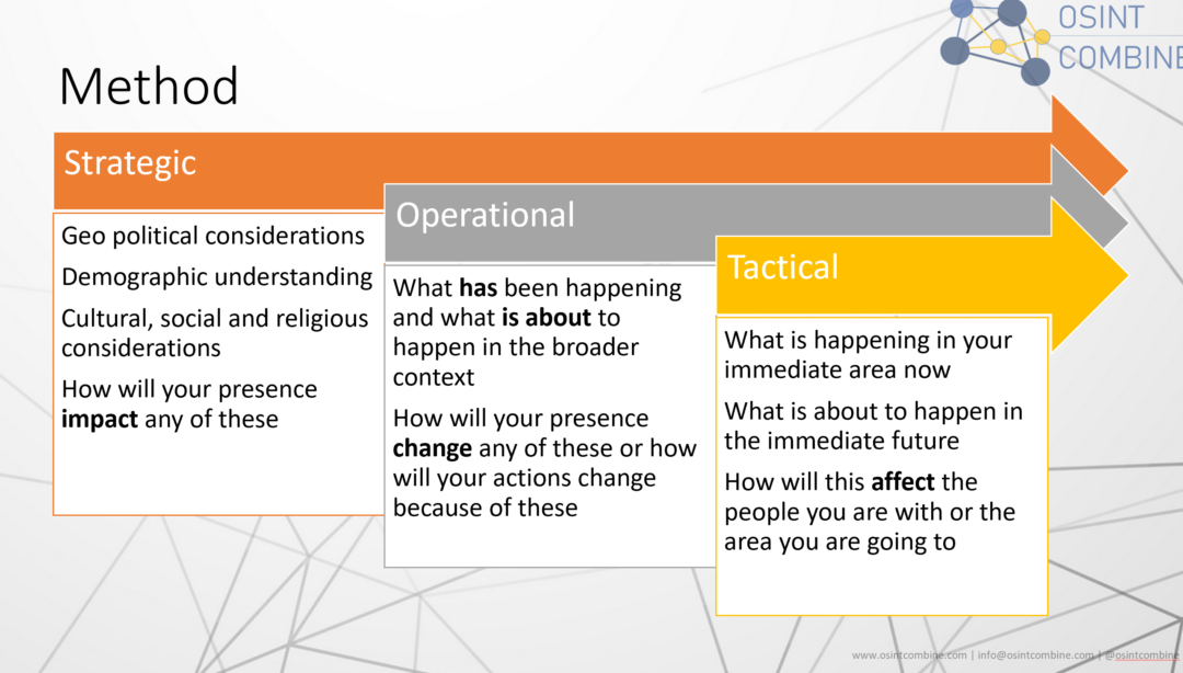
It is important to frame the different layers of strategic, operational and tactical which relate to your assessment. Each of these layers has a very important correlation to which tools provide what information. Having a cascading approach to collection and analysis will allow you to nest elements of your reporting in a logical and easy to digest manner.
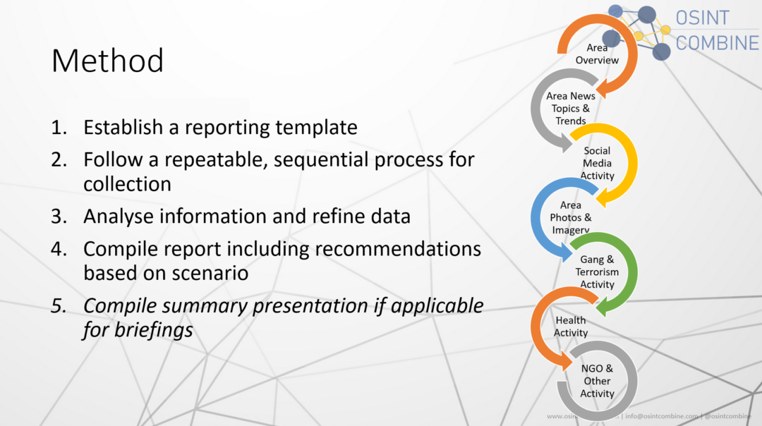
With the high-level process in hand, we will look at each section and the various sources of information that you can use to collect & then conduct analysis for your assessment.
Quick Links TL;DR There is a lot of content in this post where you may only be after quick links for information sources. Below is a “resources-on-a-page” snapshot of the content contained in this blog post. Ready on for detailed information, or use the resource pack below for quick reference:

Area Overview
Maps. Starting an area overview should naturally include mapping. A number of great mapping tools exist, but we have curated some of the most useful for specific area assessments below.
Mapping
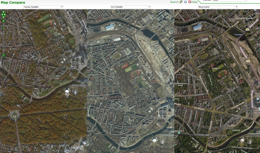
A great tool that can be useful to assess multiple map providers side-by-side is Map Compare (https://mc.bbbike.org/mc/#). This tool is great for seeing what different satellite imagery can be obtained for the same area in a single pane of glass. It is also very useful if you need to assess aspects such as slant angles of imagery to get different aspect views of a building or area.
Below you can see we are able to compare satellite imagery from Yandex, Esri and Bing side-by-side:
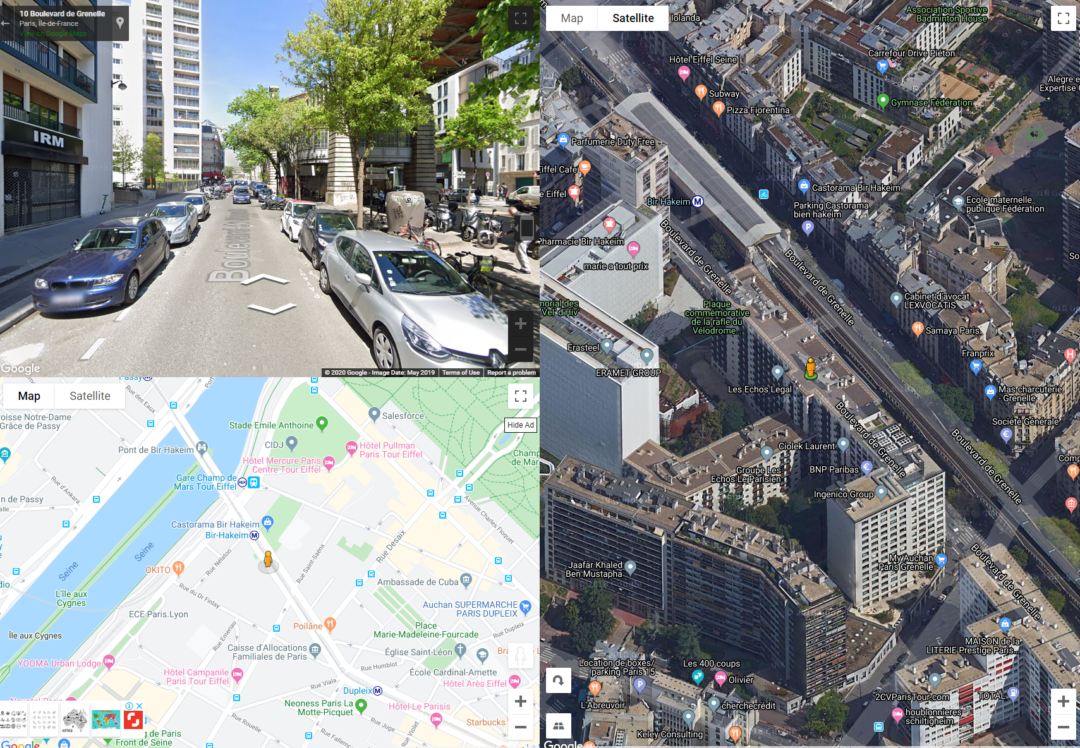
Another excellent tool is Dual Maps (https://www.mapchannels.com/DualMaps.aspx). This allows you to build an interactive map that combines Google Street View, Satellite imagery and a normal street map into a very effective interface. You can drag the “human” icon around and it will automatically move the various aspects of the map.
There are a number of other resources that can be used based on your requirements. An example can be the building of custom maps with only specific data on them. For example, you may be interested in understanding what the water-ways or traffic paths are for a particular area, and using tools at MapBox (www.mapbox.com) you can sign-up and start making maps based on your needs.
Below is a list of other useful mapping tools:
- MapBox (www.mapbox.com): Build custom maps
- OpenStreetMap (https://www.openstreetmap.org): Open source map provider
- Google Maps (maps.google.com)
- Bing Maps (bing.com/maps)
- Yandex Maps (yandex.com/maps)
- Free Map Tools (https://www.freemaptools.com): Calculate distances, areas and other useful aspects of planning for specific areas using a map based approach
Country Information
A key part of any area or country assessment should be to have a basic understanding of the political, economical, transport, infrastructure and demographics of a country.
A prime resource for this is the CIA World Factbook (https://www.cia.gov/library/publications/the-world-factbook). This resource allows you to select a country and provides detailed information for analysis across areas including geography, people & society, economy, energy, communications infrastructure, military & security, transportation, terrorism & transnational issues related to that country.
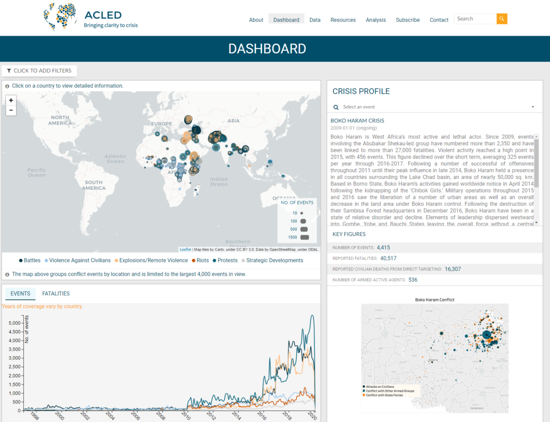
Supporting this baseline information is important with crisis information and obtaining a snapshot of the major incidents or events that are affecting an area or country. The ACLED Dashboard (https://www.acleddata.com/dashboard/) is a fantastic resource to visualize events in a country:
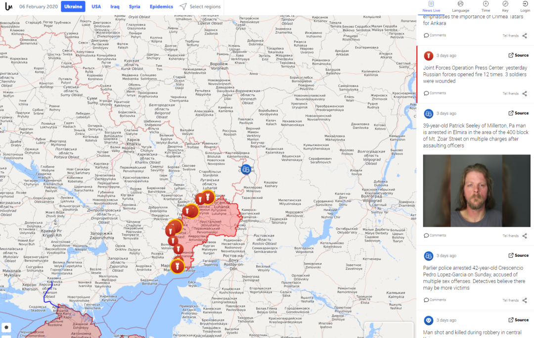
Following up with the broader overview it is important to get a snapshot at the given time for emerging events. Live UA Map (https://liveuamap.com/#) is one of the better resources which curates events of importance and includes them in a simple interface. There are issues with inappropriate ads for un-paid accounts, but the data and timely updating of information is still very valuable for area assessments & current events:
News, Topics & Trends
Any analysis of trending topics or news in an area should be objectively conducted across different perspectives. These perspectives can vary for a number of reasons including economic incentives, business requirements or simply reporting the ground truths. The key takeaway is to contrast different opinions.
An effective way to do this is to look at 3 key perspectives.
- Global news reporting (media outlets)
- Hyper-local news reporting (geo-targeted news outlets)
- Civilian reporting (social media, blogs, forums)
Across these 3 areas, you will generally find a cross-section of truth as you apply your critical thinking skills. Look for commonality (particularly in the numbers or details) so you are effectively conducting a multi-source validation (i.e. is this information worth exploring) of information which you can then pivot from to conduct verification (is it real).
Sources of information
Global news reporting is fairly obvious. Use reputable media outlets (and personal opinions on these will vary again), but it is important to note that for more localized events, the story may not reach global news. For large events where the media outlet (CNN or BBC for example) has a local office, you may be able to find sub-sets of news.
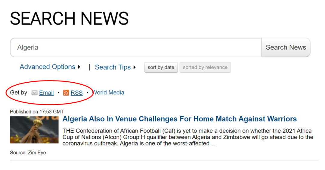
Often a better way to find global news reporting is to leverage Google Newsfeeds. Their service allows you to search via topic, location or source (allowing you to narrow down to only media outlets that you perceive as appropriate), coupled with their excellent search capabilities. https://news.google.com
Hyper-local news is harder to obtain remotely. However, there are some great resources listed below to get you started:
- EIN World News Report (https://world.einnews.com/). This site provides a collated list of news that can be filtered to a region, country or city. Additionally, once you have an area you want to watch you can set up email alerts & RSS feeds
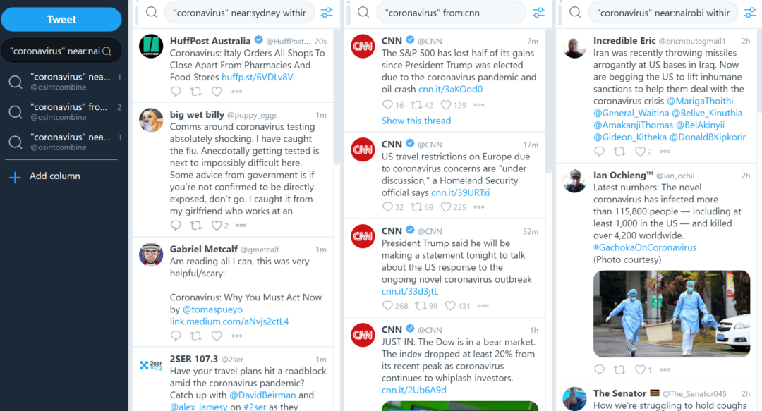
- Another great source or hyper-local news is simply using Twitter but focusing it on news outlets or reputable sources in the public sector. An example search query in Twitter could consist of: “coronavirus” from:cnn since:2020-03-11
- There used to be a great resource called newspapermap, however, this has since stopped working as Google changed their APIs and the site owner has not updated their platform as of yet. We will include the link here in case it does come back online as it’s an amazing resource: https://newspapermap.com/
Civilian reporting generally comes from social media, blogs or forums. When searching on social media, you can search directly on platforms such as Facebook, Twitter, VK etc for information, or apply Google advanced search to achieve greater scale (noting the lag in indexing if you are looking for real-time information).
Examples of Google searches:
- site:facebook.com “topic” after:2020/03/11
- site:twitter.com “coronavirus” after:2020/03/11
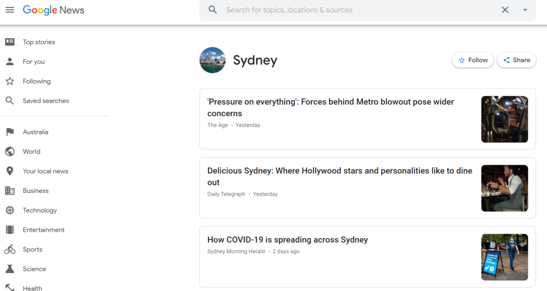
Examples on Twitter (to find information about coronavirus, since the 11th March 2020, and within 1km of Sydney):
- “coronavirus” since:2020-03-11 near:Sydney within:1km
Using TweetDeck (https://tweetdeck.twitter.com) and configuring a number of streams for civilian reporting & hyperlocal news is a great way to assess the contrast in news or reporting from an area/topic. Bellingcat has a great write-up on how to get the most out of TweetDeck available here: https://www.bellingcat.com/resources/how-tos/2019/06/21/the-most-comprehensive-tweetdeck-research-guide-in-existence-probably/
However, another perspective or dimension to analyze is what people are searching for. This shifts the view from what people are saying which you can digest, to what information is the population in a country concerned about and are rapidly googling to find answers. This can be indicative of a ground-truth that may be overlooked if the information is not being made public through tweets or posts.
Go to https://trends.google.com/trends/trendingsearches/realtime?geo=AU&category=all and select your country of choice, or modify the country code in the URL bar (geo=<country code). You can also look at yearly trends, daily trends or real-time searches depending on what is available in the target country.
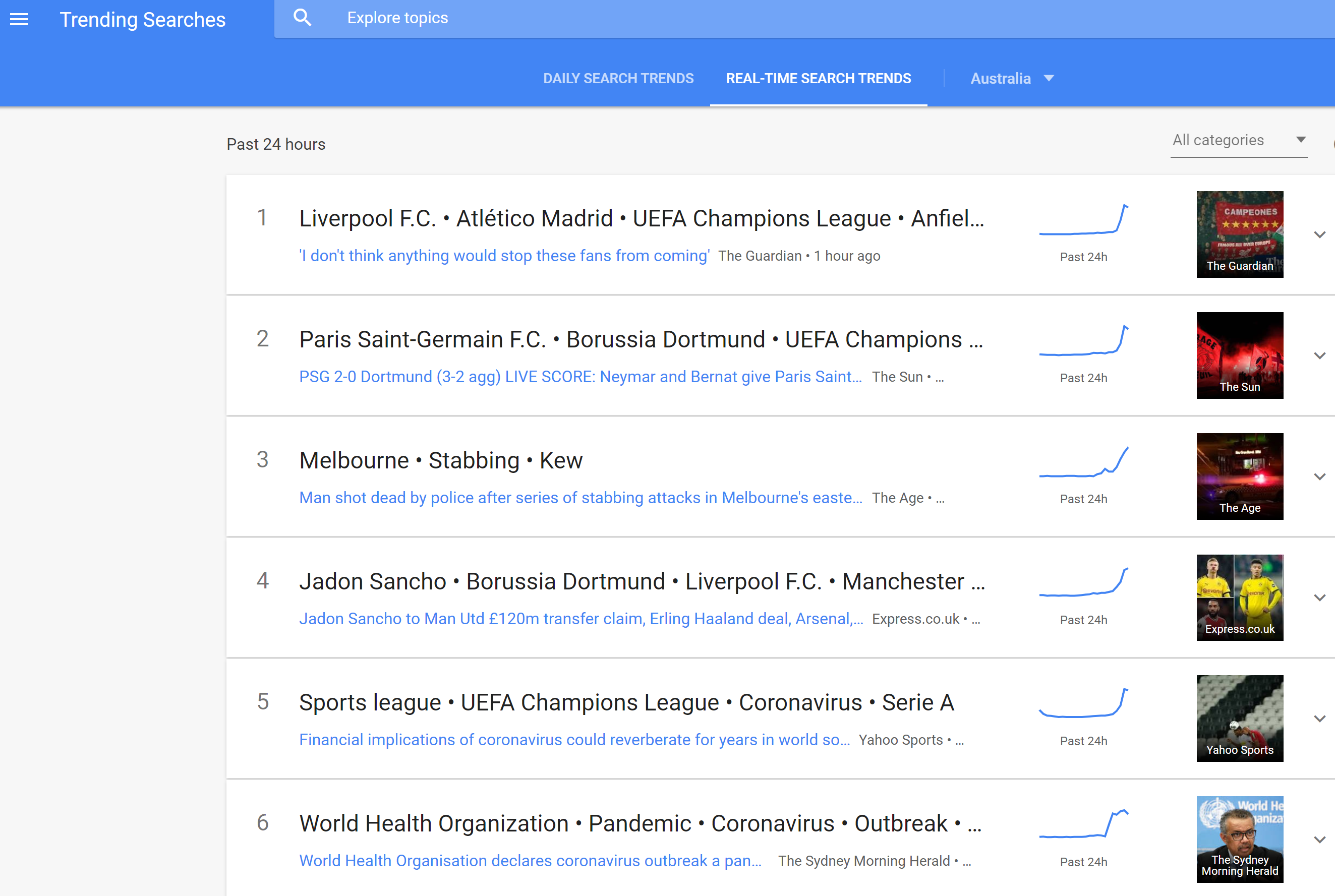
Of interest at the time of writing is people in Australia generally search more for football (yearly, daily and in real-time) than health crises or natural disasters (such as during the bush fires). It is only a single lens of search habits but does provide an interesting perspective on a populous.
Social media trending topics
A great way to find additional vectors and additional information is trending topics on social media. Twitter is still one of the better platforms for overall trends analysis due to its ability for developers to access information on the platform and present it in unique ways.
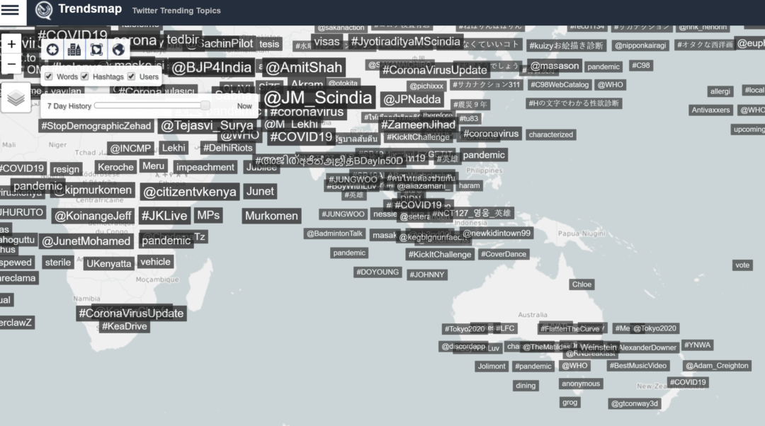
TrendsMap (https://www.trendsmap.com/) is a thousand-foot view of trending hashtags within an area with some great filter options. This can be a good pivot point to either feed into TweetDeck for monitoring or using tools such as SocialBearing (https://www.socialbearing.com) to analyze further.
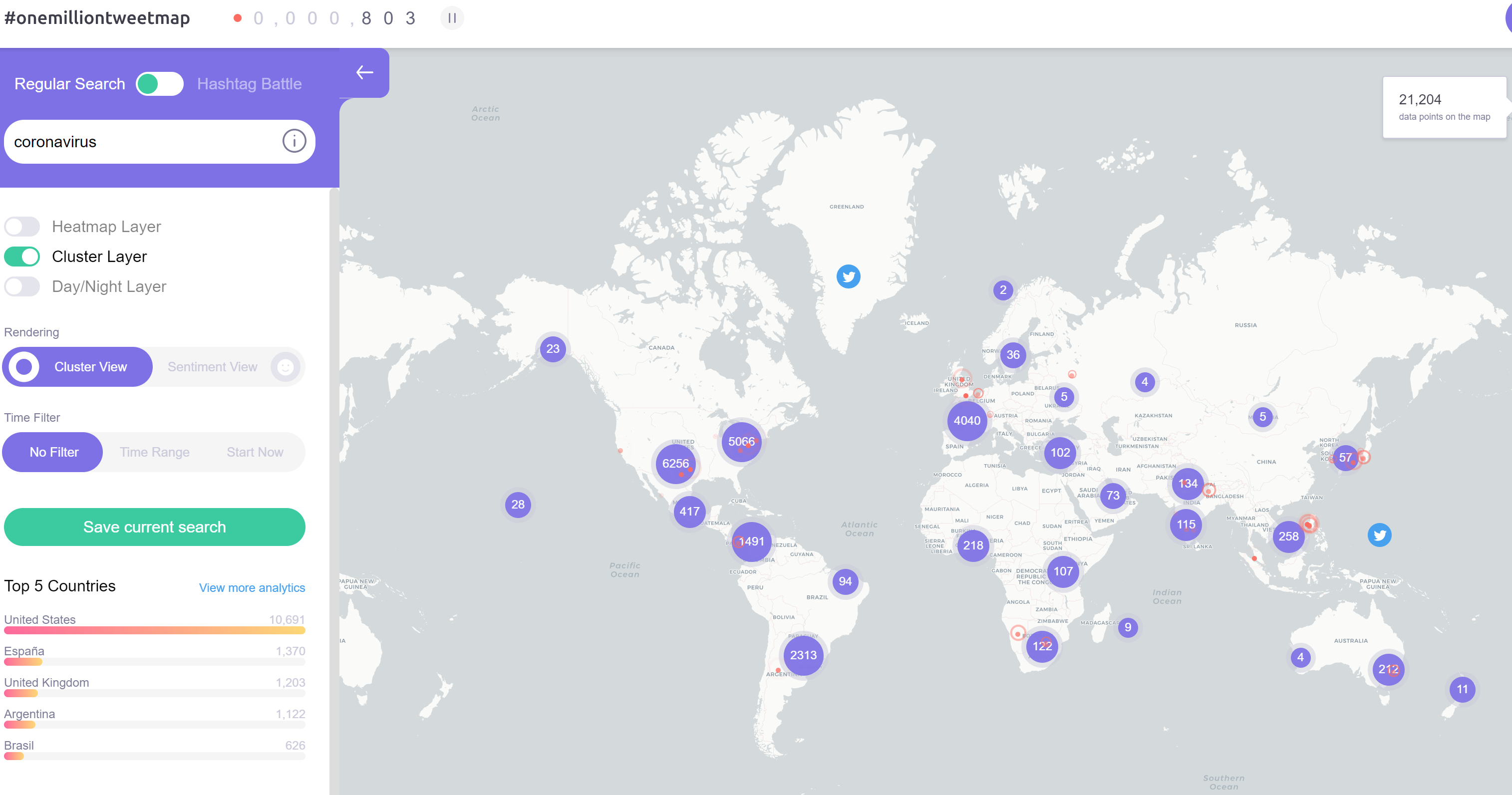
Another fantastic resource for observing topical trends (based on volume) across different countries is using onemilliontweetmap (https://onemilliontweetmap.com/). This website lets you filter via keywords & hashtags and displays a recent volume of tweets. From an analytical perspective, tracking tweet volumes based on your brand, company, or event may be of interest for exposure or interest in the countries you may visit or your staff is working in.
Below is an example of looking at coronavirus topical spread on Twitter based on the country.
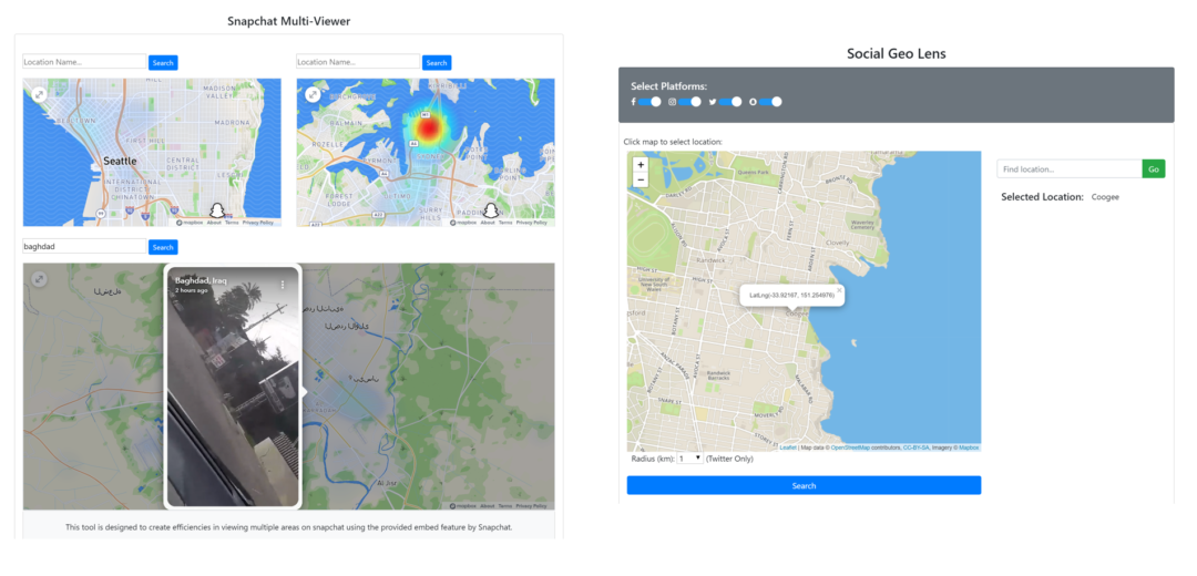
If you need to look at geofenced areas, we have created 2 tools to make that easy for you. Social Geo Lens is designed to provide a click-map option to rapidly see activity in an area (note you need to enable popups). For Instagram, if you wish to see geotagged areas you still need to search on the platform itself.
- Social Geo Lens: https://www.osintcombine.com/free-osint-tools/social-geo-lens/
- SnapChat Multi-Viewer: https://www.osintcombine.com/snapchat-multi-viewer
Threats
Every country has its share of crime or derogatory activity. Having readily available resources to assess statistics is important for an analyst when providing an assessment of risk and threats to individuals in that location.
However, there are many resources and having multiple sources means the analyst can contrast and compare which will lead to a credibility rating. Below is a list of resources for various threat natures for crime & terrorism:
Crime:
- NationMaster (crime stats per country): https://www.nationmaster.com/country-info/stats/Crime
- Numbeo (crime index & statistics): https://www.numbeo.com/crime/in/Sydney
- US Gang Activity: http://gangs.globalincidentmap.com/home.php
Terrorism:
- ESRI Terrorist Attacks Map: https://storymaps.esri.com/stories/terrorist-attacks/
- Global Terrorism Database: https://www.start.umd.edu/gtd/search/BrowseBy.aspx?category=country
- Conflict Data Map (UCDP): https://ucdp.uu.se/exploratory
- Stanford CISAC Militant Map: https://cisac.fsi.stanford.edu/mappingmilitants
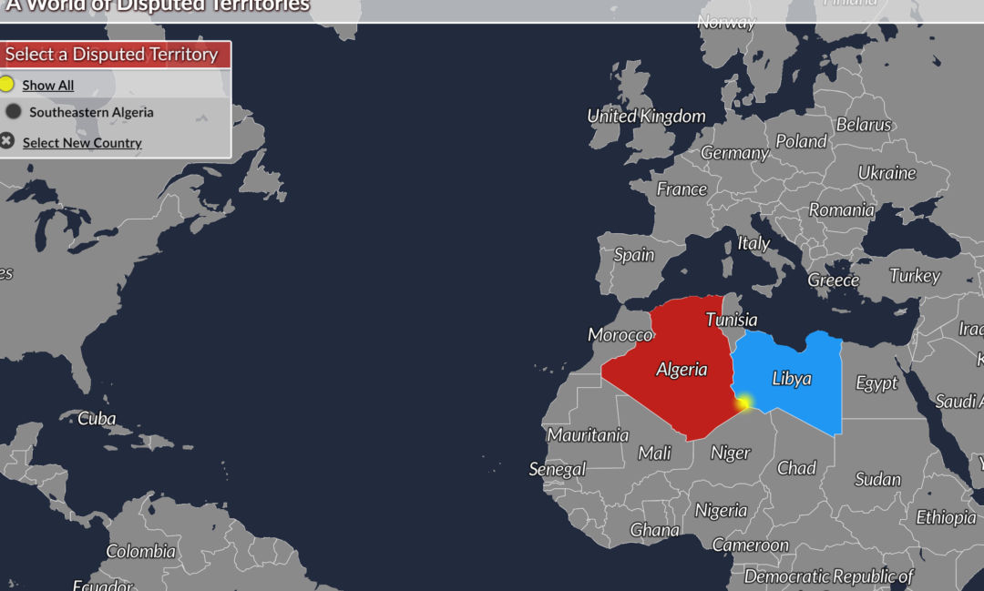
When assessing travel for staff it is important to understand high-risk areas. The disputed territory between nations is a flag for potential hot-spots that should be avoided by foreign nationals. The site Every Disputed Territory (http://metrocosm.com/disputed-territories-map.html)
Health Factors
The primary focus of a lot of organizations at the moment is health. Specifically, COVID-19. However, it is important to have a holistic resource that you can draw upon when new threats emerge.
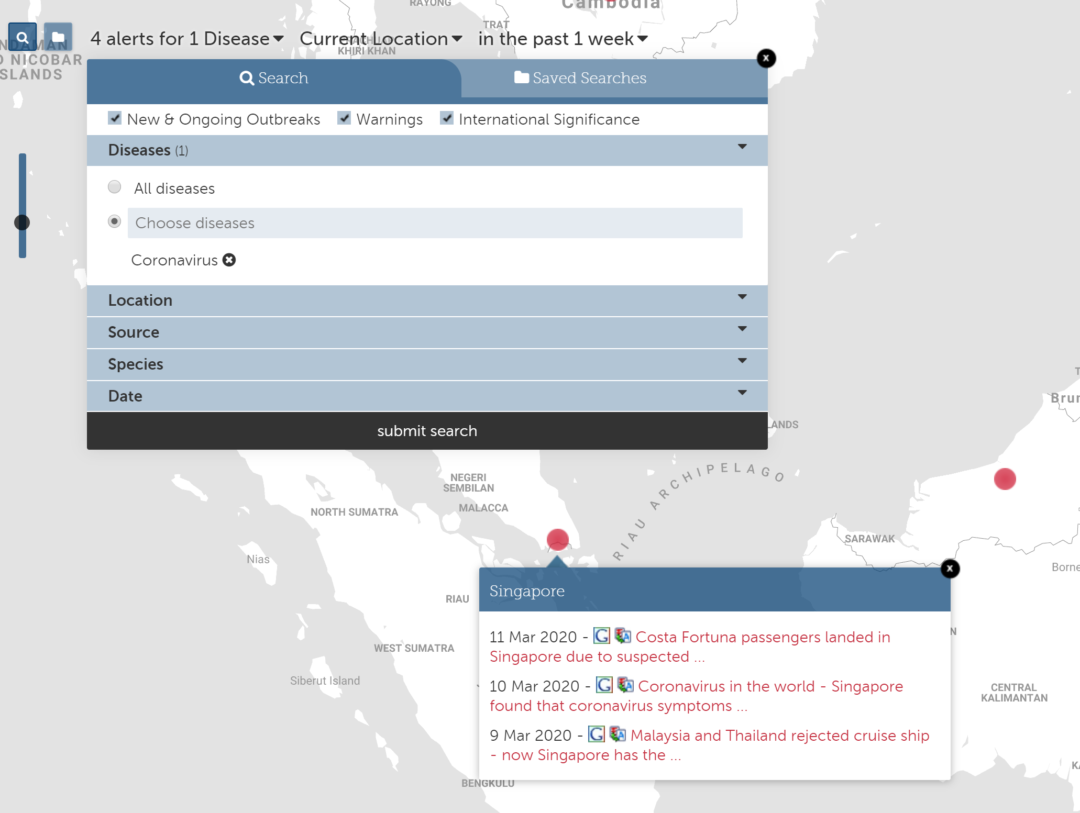
The Health Map (https://www.healthmap.org/en/) is a site provided by Boston Children’s Hospital which has input from a number of researchers, epidemiologists & software developers. It draws from “informal sources for information from disease outbreak monitoring & real-time surveillance of emerging public health threats”.
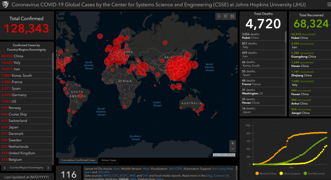
If looking specifically at the COVID-19 (coronavirus) outbreak, the best resource at present is the Johns Hopkins University map (https://gisanddata.maps.arcgis.com/apps/opsdashboard/index.html#/bda7594740fd40299423467b48e9ecf6). This is a fantastic resource to monitor.
Additionally, the raw data that is being fed into the site can be found here:
- Time series CSV files: https://github.com/CSSEGISandData/COVID-19/tree/master/csse_covid_19_data/csse_covid_19_time_series
- Daily reports CSV files: https://github.com/CSSEGISandData/COVID-19/tree/master/csse_covid_19_data/csse_covid_19_daily_reports
National health notification sites are also an important source of information & are the primary inputs for the data set above:
- World Health Organization (WHO): https://www.who.int/
- National Health Commission of the People’s Republic of China (NHC): http://www.nhc.gov.cn/xcs/yqtb/list_gzbd.shtml
- China CDC (CCDC): http://weekly.chinacdc.cn/news/TrackingtheEpidemic.htm
- Hong Kong Department of Health: https://www.chp.gov.hk/en/features/102465.html
- Macau Government: https://www.ssm.gov.mo/portal/
- Taiwan CDC: https://sites.google.com/cdc.gov.tw/2019ncov/taiwan?authuser=0
- US CDC: https://www.cdc.gov/coronavirus/2019-ncov/index.html
- Government of Canada: https://www.canada.ca/en/public-health/services/diseases/coronavirus.html
- Australia Government Department of Health: https://www.health.gov.au/news/coronavirus-update-at-a-glance
- European Centre for Disease Prevention and Control (ECDC): https://www.ecdc.europa.eu/en/geographical-distribution-2019-ncov-casesMinistry of
- Health Singapore (MOH): https://www.moh.gov.sg/covid-19Italy Ministry of Health: http://www.salute.gov.it/nuovocoronavirus
Human Trafficking
Understanding where human trafficking occurs can be an important aspect for analysts to review when at-risk staff is travelling in an area. This could relate to possible kidnapping situations or general awareness of an increased chance of crime. It can also benefit NGOs operating in areas to have greater awareness of who may be working near them or both collaboration & deconfliction to reduce fratricide in targetting.
Some resources available include:
- Human Trafficking Flow Map: http://dataviz.du.edu/projects/htc/flow/
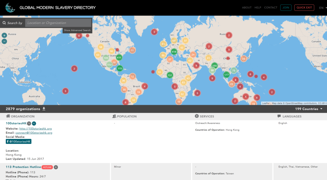
- Global Modern Slavery Directory: https://www.globalmodernslavery.org/ (this site has a list of which NGOs are active & operating, including contact information, in particular countries)
Conclusion
Conducting area assessments is an important part of many peoples jobs. This includes risk assessments, travel safety, counter-terrorism, pre-deployment operations & more. The key part is having a resource set that you can draw upon to delve into information across a number of areas. Additionally, having a methodological approach that tackles strategic, operational & tactical information succinctly will allow you to construct briefs, reports & general advice to keep people safe & make them prepared for unknown environments.
We wrote this blog to support the community in being better informed with richer information sets in the face of continual crises around the globe. Any feedback or additions are welcome.